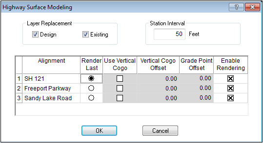
The Highway Surface Modeling window display when generating a 3D surface model by attaching the cross sections to the horizontal cogo. If there is no horizontal cogo, the surface generated will run south to north in a straight line.
|
Layer Replacement |
Check the box for the surfaces to be rendered. |
|
|
|
|
Station Interval |
Enter the distance between the stations on the generated surface. If this value is less than the cross section station interval, the program will interpolate the intermediate stations. |
|
|
|
|
Alignment |
Name of the alignments in highway mode. |
|
|
|
|
Render Last |
Determines which alignment will be generated last, which will be staged into the previously surfaced alignments. |
|
|
|
|
Use Vertical Cogo |
Check this box if you wish to use the vertical cogo for elevation, rather than the cross section data itself. |
|
|
|
|
Vertical Cogo Offset |
Enter the offset from the vertical cogo to account for the difference between the vertical profile and the cross section reference point. Enter a negative value to lower the elevation to account for sectional depth. |
|
|
|
|
Grade Point Offset |
Enter the distance between the horizontal reference and the vertical profile reference. Enter a negative value if the offset it to the left. |
|
|
|
|
Enable Rendering |
Check the box of the alignments you want to generate a surface. |
Click OK and the surfaces will be generated and return to Sitework Edit mode.