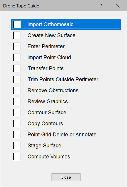
The Drone Topo Guide is designed to assist with processing Drone data. Press Guide on the menu bar and select Drone Topo to display the Drone Processing Guide. Press the G key on the keyboard to activate the guide after selecting the desired guide. The suggested data entry sequence is listed from top to bottom on the list. Below is an explanation of the commands on the Drone Topo Guide.
Import Orthomosaic |
Used to import the orthomosaic TIF file. |
|
|
|
|
Create New Surface |
|
Used to create a new surface for the drone topo survey. |
|
|
|
Enter Perimeter |
|
Switches to Entry Mode in the new drone surface, Perimeter Layer |
|
|
|
Import Point Cloud |
|
Used to import the point cloud data from the drone topo survey. |
|
|
|
Transfer Points |
|
Selects all the points in the Import Mode. |
|
|
|
Trim Points Outside Perimeter |
|
Selects all the points in the new drone survey surface, Data Lines Layer. |
|
|
|
Remove Obstructions |
Switches to Edit Mode in the new drone surface, Data Lines Layer. |
|
|
|
|
Review Graphics |
|
Switches to 3D View Mode to review the surface. |
|
|
|
Contour Surface |
Generates Contours from the drones survey data. |
|
|
|
|
Copy Contours |
|
Copies and Pastes the Contours into the Data Lines Layer and deletes the Contours Layer. |
|
|
|
Point Grid Delete or Annotate |
|
Selects All the original point cloud data for deletion or converting to Annotation. |
|
|
|
Stage Surface |
|
Stages the new drone survey data into the desired surface. |
|
|
|
Compute Volumes |
Calculates the volumes with the drones survey data. |