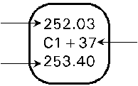
Elevation at Reference Surface

Cut/Fill amount between Reference and Difference.
Elevation at Difference Surface
In Planview Mode, there are several options which allow you to determine what information is displayed on the cut/fill label and where the labels are located. Below is an example of the cut/fill label.
|
Elevation at Reference Surface |
|
Cut/Fill amount between Reference and Difference. |
|
Elevation at Difference Surface |
|
The Options below are available under the View Menu in Planview Mode
|
|
|
|
Cut Fill Values |
Toggles the display of the Cut Fill Labels. |
|
|
|
|
|
|
|
Cut Fill Elevations |
Toggles the display of the Cut and Fill elevations on the Labels. When checked, displays cut/fill elevations and difference. When not checked, displays on the difference. |
|
|
|
|
|
|
|
Default Cut-Fill Spacing |
Spaces the cut-fill labels using a default spacing which changes the distance between labels depending on zoom level. |
|
|
|
|
|
|
|
Fixed Cut-Fill Spacing |
Allows you to change the spacing of the grid on which the labels are located. When selected, the Edit Fixed Cut-Fill Spacing window displays. Type in the distance and press OK. |
|
|
|
|
|
|
|
User Cut Fill Locations |
The User Cut Fill Locations option allows the user to enter locations manually for specific cut/fill locations to display. User locations are entered in Entry Mode in the Cut/Fill Layer of the Design Surface.
|