Earthwork 4D can generate a file type known as AGT. AGT is an ASCII line format used to transfer data lines between programs. The format is point number, Northing, Easting, Elevation, data code (optional) and label. These files are available for import into other programs, such as Graphic Grade. Below are the steps used to generate AGT files using Earthwork 4D from Edit Mode.
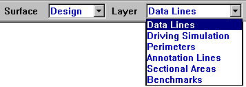
Using the Surface menu, choose the surface to work from. Then, from the Layer menu, choose which layer is to be used to create the AGT file.
Once the correct surface and layer are chosen, use the Hide, Hide All But or Show All commands to display the data to be used. Only the visible data lines of the active surface and layer are used to create the AGT file. Select Save As from the File menu.
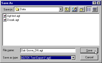
Change the file type to AGTEK Text Export (*.agt). Note that the File Name changes to reflect that this is an AGT file. A 2-letter abbreviation for the currently active surface in appended to the end of the job name to distinguish them from other AGT files created from this job.