![]()
Right Angle
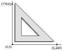
The simplest method is to draw a right angle on the plan. Place the right angle near the center of the plan sheet. Measure out along each axis with the appropriate plan scale and mark the coordinates based upon these measurements.

You can use this method if you don’t need to align the takeoff to a CAD file, survey, or a matching sheet. It also does not adjust for any plan shrinkage from duplication.
![]()
Known Distance
Another method is to find some known distances on the plan both horizontally and vertically and use those to create the coordinate system. Property Line measurements and road stationing often provide known distances. The chief advantage of this method over the former is the adjustment for any plan shrinkage.
![]()
Northings and Eastings
The best method is to use Northings and Eastings marked on the plan sheet. There are several advantages to this method. First of all, alignment to CAD files, surveys and other sheets is greatly simplified. The other advantage is that all plan shrinkage is adjusted for.
![]()