
SmartDirt Mobile App Leverages Today’s Smartphones and Tablets
SmartDirt provides a new level of processing power and 3D graphical information to the team making quick decisions on the ground—so they get the fast answers they need to keep the job moving.


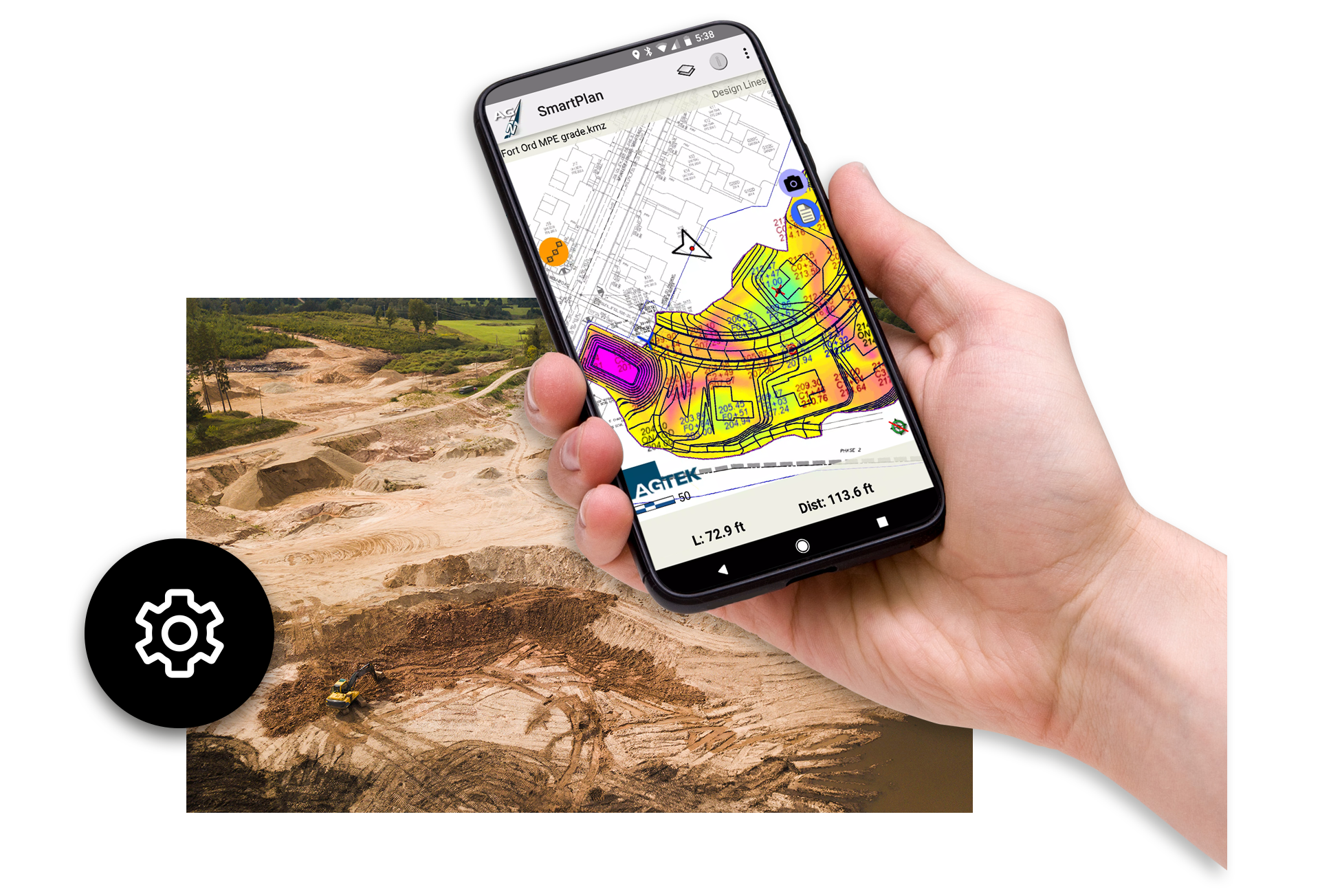
SmartDirt: Real-Time 3D Earthwork Intelligence for the Field
SmartDirt is AGTEK’s next-generation mobile application, designed to put a complete 3D model of your earthwork project directly in your team’s hands. Built for modern smartphones and tablets, SmartDirt delivers powerful, on-site visualization and instant cut-and-fill insights that help crews make faster, more accurate decisions in the field. By combining the project takeoff, plan sheets, and orthomosaic imagery from your most recent drone flight, SmartDirt provides a unified, always-accessible picture of the job.
The app instantly displays cut/fill values and elevation data based on your earthwork takeoff, drone topo, or GPS machine model, ensuring production stays aligned with design expectations.
SmartDirt enhances communication and quality control with dynamic 3D model visualizations that update as users walk the site. Teams can easily capture geolocated photos, field notes, and progress documentation, then share them across the organization through Google Earth integration. This streamlines collaboration among project managers, field engineers, estimators, and equipment operators.
Delivered under a facility license, SmartDirt ensures that everyone who needs access to real-time earthwork data can use the platform without limitation. The result is faster decision-making, improved accuracy, and a more connected workflow from office to field.

Features & Benefits
A 3D model of your job that fits in your pocket, along with the plan sheets and an orthomosaic image from your last drone flight.
3D graphical job site information displayed on your smartphone
See cut/fill information where you are standing on site
Calculate balanced areas in the field
Document progress with photos and notes
Easily share data with your team

Get Answers on the Move
SmartDirt shows cut-fill and elevation wherever you’re standing based upon your takeoff, latest drone topo, or the GPS model guiding your machines. It communicates grade and inspects models with 3D visualizations that move with you as you move across the site.

Documentation Made Easy
SmartDirt makes it easy to document progress with photos, notes and tracks that can be shared with the rest of the team in a convenient Google Earth file format. SmartDirt comes as a facility license which means that everyone who needs it can have it.
“The SmartDirt app has emerged as a significant success, particularly with our field crews. This mobile application allows superintendents and other personnel to walk job sites with a tablet, providing real-time insights into the project’s status and dynamics, even for those less familiar with earthwork specifics.”
-Williams Dirt Services
Customer stories
Hear what our customers think about AGTEK.

D Morgan expanding digital workflows with AGTEK
Adam Onyett from D Morgan explains how they believe that AGTEK will become the single solution for them.

Elder Corporation managing production with Trackwork
Shawn Swygman of Elder Corporation takes a deep dive into their use of AGTEK, specifically the Trackwork module.

Cyclone Land Development
For over 20 years Cyclone Land development has been partnering with AGTEK to provide digital solutions to help simplify the construction process.
SmartDirt Frequently Asked Questions
SmartDirt is a mobile 3D earthwork app that gives field teams real-time cut and fill information, drone topo data, plan sheets, and model visualization directly on their smartphone or tablet.
SmartDirt uses your earthwork takeoff, drone topo, or GPS machine control model to show accurate cut and fill values wherever you stand on the site.
Yes. SmartDirt provides fully interactive 3D graphical visualizations that move with you as you walk the jobsite, improving interpretation and communication.
Yes. SmartDirt integrates orthomosaic images from your latest drone flight to enhance accuracy and site awareness.
SmartDirt runs on modern smartphones and tablets, leveraging their processing power and graphics capabilities for high-quality 3D visualization.
By showing real-time elevation, cut/fill, and model data, SmartDirt provides instant answers so crews can keep production moving without delays.
Yes. Users can capture photos, notes, and GPS tracks, which can be shared with the team through Google Earth.
SmartDirt supports GPS machine models, allowing crews to compare actual conditions to guided design data.
SmartDirt’s accuracy depends on the quality of your takeoff, drone topo, and GPS model inputs, providing consistent and reliable field measurements.
Yes. SmartDirt supports planning, tracking, verifying, and communicating earthwork progress throughout the project lifecycle.
No. SmartDirt is provided under a facility license, meaning everyone who needs the app can access it without individual seat restrictions.
SmartDirt extends AGTEK’s takeoff and modeling capabilities to the field, ensuring crews work from the same data used for estimating and planning.
Yes. SmartDirt is designed for intuitive use, enabling non-technical field staff to quickly access 3D data and elevation insights.
SmartDirt is ideal for grading, excavation, site development, utilities, infrastructure, and any earthmoving operations requiring real-time field intelligence.
SmartDirt’s visualizations, shared notes, and exportable documentation help teams collaborate more effectively across departments.

Training and Support at Your Fingertips
Get the most out of your AGTEK tools. Choose from web-based trainings or in-person classes for beginner, intermediate, or advanced learners. Our Community is here for you 24/7 with downloads, manuals, Tech Tips, and more.
Get in touch with our team
Let us know if you have questions about AGTEK sales, training, or products. A representative will be in touch soon.
-
 Connect with an AGTEK expert
 -
 Get your questions answered fast
 -
 Schedule a strategy call
 -
 Start winning more jobs with AGTEK