Home > Surfaces and Layers > Layers > New Surface Layers
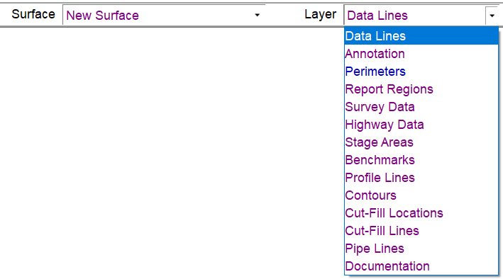
New Surfaces are composed of several layers. The example below shows the available Surface Layers. A brief explanation about the layers is found below.
Data Lines |
|
Data Lines contain all the lines, points and labels. Data contained within this layer is used to generate the 3D surface. |
Annotation |
|
This layer is used to add reference line data that is not included in the surface trimesh calculation. |
Perimeters |
|
Perimeters may be added to all new surfaces to define the area to be calculated. |
Survey Data |
|
This is temporary data used with the Apply Survey command to stage the Survey Data to the Data Lines layer. |
Stage Areas |
|
Data used to update the surface using Stage Over-Ex from the Over-Ex Guide. Once the data has been staged, the Stage Areas layer become empty. |
Benchmarks |
|
Contains any control points (Benchmarks) specified. These points are often used for re-scaling with grading plans or with AGTEK's Graphic Grade program |
Profile Lines |
|
Used to create profiles and cross sections across the job. |
Contours |
|
The Layer in which contours are created when using the Contour Surface command. |
Cut/Fill Labels |
|
These are spots entered to be used in conjunction with the User Cut-Fill Locations located under the View Menu in Planview Mode. |
Highway Data |
|
This layer contains any data generated by Highway mode. |
Cut/Fill Lines |
|
This layer contains any lines generated using the Cut/Fill Lines option. |
Pipe Lines |
|
The Pipe Lines layer contains any data entered as a Pipe Line in the file. |
Documentation |
|
Contains user added Notes or 3D Notes entered in Sitework 4D or Notes and Photos imported from SmartPlan. |